

Spectrum Management, Radio Coverage and Radar Planning
Wireless communications management is critical for our increasingly interconnected world. WRAP™, an Altair® Feko™ component, maximizes the benefits of emerging communication technologies for individuals, businesses, and society. With its integrated capabilities, WRAP simplifies the technical and administrative tasks required for radio and radar coverage planning over large regions, spectrum management, interference analysis, frequency administration, and network monitoring. And WRAP’s optimization tools help users achieve desired network performance goals without the hassle and cost of large planning teams.
Learn More About Altair Feko
Spectrum Management and Monitoring
WRAP streamlines the complex task of managing valuable radio spectrum assets to provide maximum utilization and optimal performance. With support for large national and international frequency databases, WRAP's propagation models ensure comprehensive coverage across the entire radio spectrum. And with International Telecommunication Union (ITU)-compliant calculation and coordination methods, WRAP ensures compatibility with spectrum regulations while quickly identifying and resolving interference issues in remote and densely collocated scenarios.
With WRAP's extensive spectrum regulation toolkit, users can efficiently perform technical coverage administration, interference management, and spectrum optimization with a flexible, robust solution.

Defense and Mission Planning
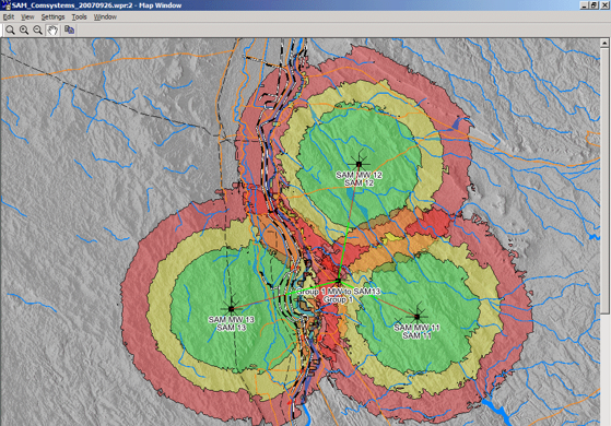
WRAP applications for defense and mission planning deliver essential tools to meet the frequency and radio network planning requirements for defense forces, regardless of the challenging conditions they face; these include difficult terrain, advanced warfare systems (AWS), radio jamming, co-site interference, and/or eavesdropping. Supporting central, regional, and command units with strategic spectrum management, new system design and procurement, and frequency management in line with national and international allocations, WRAP customers can strategize their tactical planning for short-term and long-term spectrum management with a focus on successful radio communications, electronic warfare, and radar coverage.

Civil Aviation Radio Planning
Air traffic radio-based data transfer and communication always demands comprehensive levels of safety. WRAP's analysis and computational tools fulfill the most stringent communication criteria for managing the civil aviation frequency spectrum. With WRAP, users can optimize for full radio communication coverage, navigation, and airspace surveillance. Additionally, users can analyze radio communication coverage in air traffic control radio systems and calculate the frequency assignment for minimum interference from intermodulation, radio broadcasting, and aeronautical sources.
WRAP has the necessary toolkit to analyze and solve problems before they occur to meet the demanding radio-based communication standards essential for secure skies.
Ready to maximize your network performance?
Contact Us
Public Safety Network Planning
When human lives are at stake, teams need reliable communication networks that have excellent coverage and the capacity to operate through unexpected events. WRAP handles these challenges and more.
With WRAP, users can establish public safety networks with careful, accurate, and scalable planning that meets performance goals and ensures optimum location of base stations, repeaters, and backbone microwave links. WRAP’s comprehensive tools also let users optimize networks with respect to cost, coverage, spectrum regulation, and utilization to handle the most stringent requirements. From diverse radio communication systems to common radio network planning, WRAP handles it all.

On the Seas and Along the Railway Tracks
WRAP’s planning and analysis tools for full-coverage maritime radio networks, surveillance, positioning, and communication secure safety and vessel-tracking at sea. With WRAP, users can handle all network situations: leverage geographical data and advanced radio wave propagation models to identify blind spots; determine optimal locations for radars and coastal radio stations to ensure the best coverage of territorial water and coastal zones; perform interference analysis for locations where several radio stations are collocated; manage frequency; and coordinate radio coverage with neighboring countries.
For railway communication networks, WRAP offers integrated tools that let users plan for coverage, interference, redundancy – even in the event of base station failures – and account for traffic properties as well as microwave point-to-point/multipoint links for backbone network planning. Capabilities such as the wireless network cost-and-coverage optimizer automatically places base stations at optimal locations and reveals optimum antenna heights. WRAP also provides frequency assignment and analysis tools that ensure minimum interference and maximum communication reliability.

Broadcasting and Microwave Network Planning
Managing the digital network evolution is complex with requirements for efficiency and spectrum regulation and service sharing. WRAP’s spectrum management and monitoring applications for wireless network planning handle these challenges and more, including service-area optimization, national and international coordination, and planning for audio and video broadcasting networks and their associated land and satellite stations.
For planning fixed and microwave networks, you need tools that can search sites, profile paths, define candidate relay sites, and calculate connectivity and link availability. WRAP can do it all – as well as optimize your network for interference handling, frequency assignment, capacity, spectrum efficiency, and cost. WRAP applications also cover microwave links for point-to-point/multipoint networks, both for link design and interference coordination with other stations.
Use Altair Units to access WRAP – and more than 150 Altair software and partner products.
Learn MoreFeatured Resources
Radar and Radio Systems Coverage Optimization
Using simulation to predict, analyze, optimize, and plan the coverage given by radio and radar systems is key to reduce development and planning times together with costs. Also, in some cases, this is the only feasible approach to identify and fix communication issues. This webinar overviews simulation strategies for propagation analysis in complex environments, including among others large-scale terrain, cities, or buildings with interior detail. Additionally, the effects of interference and jamming will be covered and how the frequency allocation for a system with many transmitters can be optimized automatically.
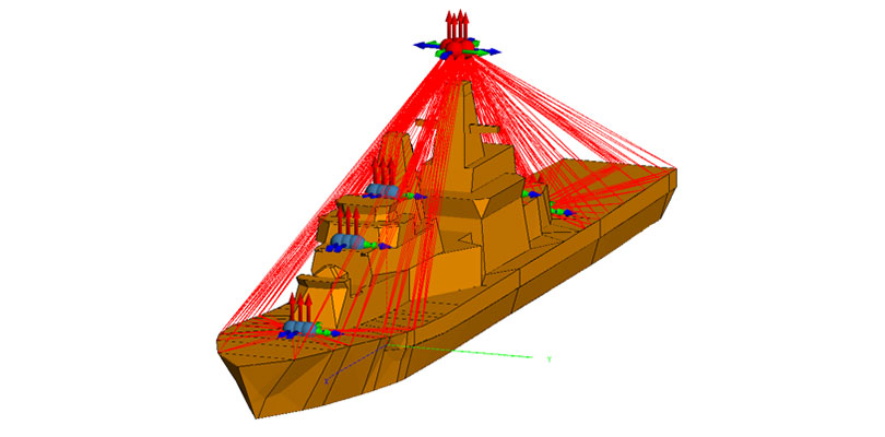
Large Platform Co-site Interference Mitigation
(a) accurate determination of the coupling between antennas over a broad frequency range, even if platforms are complicated, and no direct line of sight may exist,
(b) evaluation of the impact of non-linear electronic effects including harmonics, intermodulation, IF breakthrough, image frequency, Tx and Rx spectra, and receiver blocking.
Altair’s full system solution for analysis of co-site interference will be presented in this webinar, along with a practical example where an interference problem is identified and eliminated.

Electromagnetic Simulation for Electronic System Design in Aerospace and Defense
The aerospace and defense industry relies heavily upon advanced electronic systems for field communications, control, targeting, threat detection, asset tracking, health monitoring, and theater operations. These advanced electronic systems often require multiple, high-fidelity antennas. Those antennas, in turn, require interference free integration for maximum signal strength and reliability.
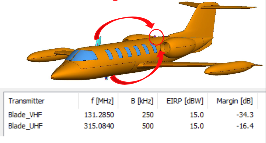
Collocation Interference Analysis Workflow And Exercise
RF co-site interference occurs when two or more co-located RF systems affect one another’s smooth operation. This normally occurs when two or more RF systems are operating physically close to one another and they are operating in such a way that one of the transmitters negatively impacts one or more receivers. This document explains you the workflow and includes an exercise following the steps to solve a co-site interference problem from the creation of the transmitters, receivers and antennas, through the stations and coupling loss matrices, and to the analysis.
